New Open-Source Global Planted Forest Dataset🌲📊
The new Global Planted Forest Dataset maps 447 tree species in 91 countries. Key for Lacey Act, illegal logging, and forest nerds everywhere!
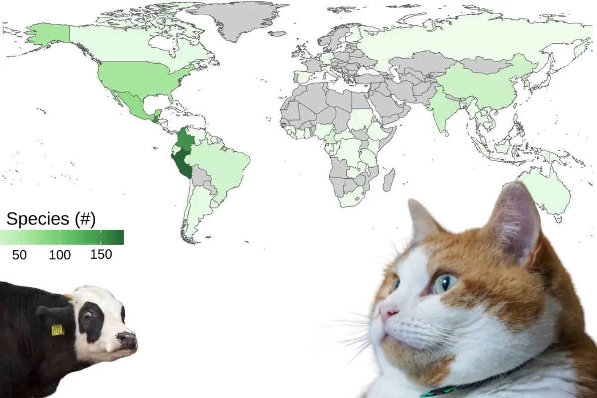
91 Countries, 447 Species 🌍🌿
A recent study by Richardson et al. (2024) has taken on the daunting task of mapping out all timber plantations worldwide, breaking down planted forests species by species. Incredibly daunting, for sure—but why? Why map out planted forests at the species level?
Planted forests are key to sustainable timber production, biodiversity conservation, and legal trade compliance, but until now, detailed data was scarce. While tools like Global Forest Watch (GFW) excel at tracking overall forest cover—including areas of increased tree cover—they don’t provide the deep, species-specific insights needed to distinguish planted forests from natural ones. This new dataset fills that gap, complementing GFW’s big-picture monitoring with a zoomed-in view of planted forests, covering 91 countries and 447 species.
It offers clear, actionable insights to help stop illegal logging, protect ecosystems, and enforce international timber regulations. Whether you’re a policymaker, conservationist, or supply chain manager, or just nerds like us, this is a resource you’ve been waiting for. 🌳✨
Illegal Logging, and Why Biodiversity Data Matters🌳🛡️
Illegal logging is a pretty big environmental headache—with implications for biodiversity, ecosystems, and climate stability. 🌡️ The distinction between planted and natural forests is essential for enforcing regulations like the Lacey Act and the EU Deforestation-Free Products Regulation. Without precise species-level data, we're all kind of stuck fumbling in the dark. This dataset steps in as the flashlight, shining a light on compliance, ecosystem protection, and climate action.
Lacey Act? Is that Broadway? 💃
The Lacey Act, a U.S. law enacted in 1900 and later amended, prohibits trade in illegally sourced plants and wildlife. It requires importers to declare the origins and species of timber products, making accurate, species-level data crucial for compliance. 🌎
Meanwhile, the EU Deforestation-Free Products Regulation, adopted in 2023, ensures that products like timber, coffee, and soy sold in the EU don’t contribute to deforestation or forest degradation. It imposes strict traceability and due diligence requirements on companies, relying on accurate data to verify supply chains.
Thank you to the @ViolinSociety and the Alliance-International for inviting IWPA Executive Director Ashley Amidon to speak to speak about the Lacey Act! This is the last IWPA presentation under our @USDA_APHIS grant, but it’s not to late to grab a FREE Lacey Act course by Dec 1! pic.twitter.com/zuUOsyQ1L9
— International Wood Products Association (IWPA) (@iwpawood) November 22, 2024
Violin Society educates us on the Lacey Act.
What’s Happening: Advancing Timber Trade Regulations with Geospatial Forest Data 🗺️📌
This project introduces two complementary datasets to fill major data gaps:
- Polygon Data:
- Pulled from the Spatial Database of Planted Trees.
- Includes 27 countries and 253 species, with detailed geospatial boundaries for planted forests.
- Non-Polygon Data:
- Compiled from scientific and governmental sources.
- Covers 91 countries and 447 species, though it lacks mapped boundaries.
💡 Key Features:
- Regulatory support tailored for CITES and local trade restrictions.
- Integration of spatial and non-spatial data for better forest monitoring.
This blend of geospatial precision and location-specific data is advancing timber trade regulation and global conservation efforts.
The Utility of this Dataset 🌏🛠️
This dataset delivers value across multiple fronts:
- Policy Enforcement: Governments can track timber origins to distinguish legal planted sources from restricted natural ones.
- Biodiversity Conservation: Conservationists gain species-level insights, essential for monitoring biodiversity and habitat health. 🐾
- Supply Chain Transparency: Businesses can trace timber sources to comply with international regulations. 📦
- Educational and Research Opportunities: Researchers can analyze global forest trends and design conservation strategies.
- Data Accuracy: The combination of polygon and non-polygon datasets enables robust cross-validation for higher confidence in decisions.
FSC is evolving and we want to hear from you! Join our public consultation to strengthen FSC standards, align with the EU Regulation on Deforestation-free Products (EUDR), and continue fighting deforestation globally. Open until 1 March 2024. pic.twitter.com/C8onxkxgfS
— FSC Canada (@FSC_Canada) February 19, 2024
EU regulations are changing the way we do business.
Acknowledging the Limitations 🤔⚠️
These are groundbreaking resources, but they have their limits. Here’s what to keep in mind:
- Taxonomic and Spatial Gaps: Not every species or region is included (yet).
- Temporal Constraints: The dataset isn’t real-time, so it may not reflect recent changes.
- Information gaps: While the polygon and non-polygon data can be used together for cross-validation, they offer two distinct types of location-based information with different levels of granularity.
- Coverage and Enforcement Issues: Regions with weaker reporting systems may still fly under the radar.
Use it as a foundation, not a silver bullet, and build from there.
Open-Source Geospatial Forest Data for Global Conservation 🌐💡
By adopting open-source principles, this dataset makes life easier for researchers, governments, and conservation organizations. The code is all openly available on Zenodo.
It’s a versatile validation tool for enforcing timber trade policies, protecting biodiversity, and educating future environmental leaders. And it’s built to adapt, ensuring relevance as forest management challenges evolve.
In short: this is the kind of data-driven innovation the world's forests need. 🌲
Source 📚
Richardson, S.B., An, L., Pollack, S.E. et al. Global planted forest data for timber species. Sci Data 11, 1269 (2024). https://doi.org/10.1038/s41597-024-04125-y. Retrieved from https://www.nature.com/articles/s41597-024-04125-y#citeas
Edited by Chris Harris

This work is licensed under a
Creative Commons Attribution 4.0 International License.
